Even after a handful of years in the commercial space, off-the-shelf equipment and software for the drone / UAS community remains immature for the needs of investigative geoscience. But the technology is close- several (re)configurations are available to extend current drone tech for use into real-world geoscience applications.
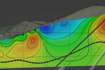
Follow the adventure of a 1000 line-km heavy-lift drone VLF survey in all weather conditions in the northern Yukon and discover the tricks that made it possible.