MineAR app
iOS & Android 3D GIS Viewer
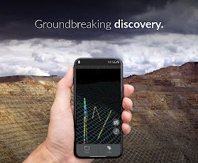
Immerse yourself within your GIS data in 3D, virtually or in actual real space.
MineAR is a 3D mapping app for your smartphone that allows you to upload GIS data get within in, viewing it alongside your surrounding terrain and geography.
Zoom and play from the office or home or snap the viewer to your location in the field.
Stylize your data on the fly using preset tools within the app.
Turn on and off different layers, and toggle the camera.
Already included: full earth elevation wire frame, roads, rivers and trails. Add your mining, geography, lands, geology, drilling, sampling, environmental data and get started today!
Filetypes supported: csv, gpx, kml, geojson, shp, obj
Blender3D GIS Drill Hole Importer
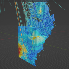
Use this easy add-on for Blender3D to:
Import your drill holes, soil or rock sample data.
Easily colorize the drill or sample assays, intercepts or other data on the fly by attribute using a variety of available styles.
Drill hole importer accepts drill data as separate collars, survey, from-to data sheets. Drill hole importer also accepts data from a single x,y,z data csv file.
Create custom models- 3D surface volumes- of your drill holes, soil or rock sample data.
Easily colorize the volumes on the fly using a variety of available styles.
Volume modeler accepts drill or sample data imported using the Drill Hole Importer add-on.
Export your volumes as obj for import into the MineAR smartphone app, Leapfrog 3D, or other 3D GIS software applications.
*Resource models produced by this add-on should not be used as NI 43-101, JORC, or similar equivalents without confidence testing.
Blender3D
Open-source, desktop 3D modeling software for Windows, Mac and Linux.
Powerful tool bringing 3D to the world.