3D modeling is an enormously useful method for investigating relationships among surface and subsurface data, and searching for new valuable insights. From shovel to mine, geology to geochemistry and geophysics, visualizing the correlations among data support the innovation and discovery required for effective exploration and decision making. However, several companies […]
What is GIS? “Geographic Information System”- a system of managing geospatial data. No longer just desktop software, leverage the power of the cloud, coding, and open source software to scale GIS data! Why is GIS stuck in the dark ages? Because GIS has been taught / used by millions of […]
Even after a handful of years in the commercial space, off-the-shelf equipment and software for the drone / UAS community remains immature for the needs of investigative geoscience. But the technology is close- several (re)configurations are available to extend current drone tech for use into real-world geoscience applications. Follow the […]
Today, most companies share a common goal: gain insight from data. From bitcoin to block chain, new buzzwords and acronyms emerge every few months that promise a deeper understanding and a better life. Most ‘AI’ examples that we hear of now- from self-driving cars to facial recognition- seem out of […]
Our world isn’t flat- so why are our maps? Learn about MineAR, an app for iOS and Android that enables users to import 2D and 3D GIS data and view in real space. Go beyond virtual and use this professional tool to extend the office into the field; immerse yourself […]
So, you have located a mining claim, put your stake in the ground, now what? We have put together a step-by-step guide to successfully file a mining claim within the county and state the claim is located in.
Ethos Geological recently performed a drone survey for a company covering a large area of interest in Haiti. From high winds to sunburns and beautiful white sand beaches, this project tested our faculties in many ways! Read on to find out some of the most amazing results from the trip, […]
Joselyn Mcphie et al. produced this amazing text on interpreting volcanic textures in the field. No exploration geologist should be without. And it’s more than just interpreting volcanic textures- they outline a great method of describing any rock a geologist might find in the field, using a common terminology […]
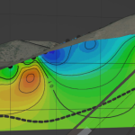 3D modeling is an enormously useful method for investigating relationships among surface and subsurface data, and searching for new valuable insights. From shovel to mine, geology to geochemistry and geophysics, visualizing the correlations among data support the innovation and discovery required for effective exploration and decision making. However, several companies […]
 What is GIS? “Geographic Information System”- a system of managing geospatial data. No longer just desktop software, leverage the power of the cloud, coding, and open source software to scale GIS data! Why is GIS stuck in the dark ages? Because GIS has been taught / used by millions of […]
 Even after a handful of years in the commercial space, off-the-shelf equipment and software for the drone / UAS community remains immature for the needs of investigative geoscience. But the technology is close- several (re)configurations are available to extend current drone tech for use into real-world geoscience applications. Follow the […]
 Today, most companies share a common goal: gain insight from data. From bitcoin to block chain, new buzzwords and acronyms emerge every few months that promise a deeper understanding and a better life. Most ‘AI’ examples that we hear of now- from self-driving cars to facial recognition- seem out of […]
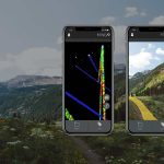 Our world isn’t flat- so why are our maps? Learn about MineAR, an app for iOS and Android that enables users to import 2D and 3D GIS data and view in real space. Go beyond virtual and use this professional tool to extend the office into the field; immerse yourself […]
 This year we’re going virtual. Come say hi at our digital booth, AME’s Roundup Conference Jan 18-21.
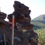 So, you have located a mining claim, put your stake in the ground, now what? We have put together a step-by-step guide to successfully file a mining claim within the county and state the claim is located in.
 Ethos Geological recently performed a drone survey for a company covering a large area of interest in Haiti. From high winds to sunburns and beautiful white sand beaches, this project tested our faculties in many ways! Read on to find out some of the most amazing results from the trip, […]
 Joselyn Mcphie et al. produced this amazing text on interpreting volcanic textures in the field. No exploration geologist should be without. And it’s more than just interpreting volcanic textures- they outline a great method of describing any rock a geologist might find in the field, using a common terminology […]