Interested in training? To learn more about some unique techniques and methods?
Browse the content below, or contact us today for a quote for customized training sessions, suitable for small size and larger groups (5-20), in person or remote.
Training Topics
- Structural Geology (stereonets and structural targeting for beginner, intermediate and advanced levels)
- Geochemical Fingerprinting (factor analyses, statistics, and geochemical plots for protolith and genesis)
- Blender3D Modeling for geoscientists (using free, open-source software for geologic modeling and drill hole planning/viewing)
- Drone Surveys (from photogrammetry to long lining, tips and tricks for planning, executing, and processing a survey)
- GIS at Scale- Cloud Based Solutions for the Corporation (how to design, develop, and deploy a scalable GIS data warehouse and delivery solution)
Training Videos
- Blender3D: Free and powerful 3D software for geology and mining modeling
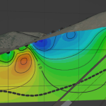 3D modeling is an enormously useful method for investigating relationships among surface and subsurface data, and searching for new valuable insights. From shovel to mine, geology to geochemistry and geophysics, visualizing the correlations among data support the innovation and discovery required for effective exploration and decision making. However, several companies […]
 - Beyond ESRI- A Modern (and Open Source) GIS Technology Stack
 What is GIS? “Geographic Information System”- a system of managing geospatial data. No longer just desktop software, leverage the power of the cloud, coding, and open source software to scale GIS data! Why is GIS stuck in the dark ages? Because GIS has been taught / used by millions of […]
 - Elevating Site: 1000 line km of heavy lift drone flights in inaccessible terrain, northern Yukon 2020
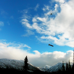 Even after a handful of years in the commercial space, off-the-shelf equipment and software for the drone / UAS community remains immature for the needs of investigative geoscience. But the technology is close- several (re)configurations are available to extend current drone tech for use into real-world geoscience applications. Follow the […]
 - Distilling AI: a short primer on real world predictive techniques in the geosciences
 Today, most companies share a common goal: gain insight from data. From bitcoin to block chain, new buzzwords and acronyms emerge every few months that promise a deeper understanding and a better life. Most ‘AI’ examples that we hear of now- from self-driving cars to facial recognition- seem out of […]
 - MineAR mobile app projects your GIS data in 3D virtual or augmented reality surrounding you… get immersed!
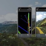 Our world isn’t flat- so why are our maps? Learn about MineAR, an app for iOS and Android that enables users to import 2D and 3D GIS data and view in real space. Go beyond virtual and use this professional tool to extend the office into the field; immerse yourself […]
 - Volcanic Textures (Mcphie, 1993)
 Joselyn Mcphie et al. produced this amazing text on interpreting volcanic textures in the field. No exploration geologist should be without. And it’s more than just interpreting volcanic textures- they outline a great method of describing any rock a geologist might find in the field, using a common terminology […]